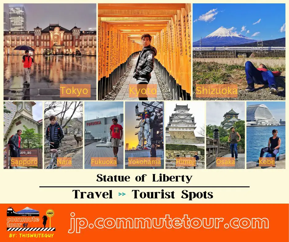
Statue of Liberty Details, Nearest Stations and How to Commute
Statue of Liberty
Encounter a replica of the Statue of Liberty in the heart of Tokyo. Located on Odaiba Island, this iconic symbol stands as a testament to the enduring friendship between Japan and the United States. Marvel at its grandeur, capture memorable photos, and appreciate the cultural significance of this landmark in Tokyo.
Statue of Liberty is located in Tokyo and the nearest train station is Daiba Station. Other stations within 3.0 km from Statue of Liberty include: Aomi, Ariake Tennis-no-Mori, Kokusai-tenjijo, Odaiba-kaihin-koen, Shibaura-futo, Telecom-Center, Tokyo Big Sight, Tokyo International Cruise Terminal and Tokyo-Teleport.
The train lines passing along these stations include: Rinkai Line and Yurikamome Line.
Travelling today or planning to commute going to Statue of Liberty? Learn more about Statue of Liberty Schedule.
Find out how to go to Statue of Liberty using google maps and commute by train or bus
NOTICE: The fares and schedules listed here may subject to change without prior notice. Pls check with the companies for the updated details.
CommuteTour is in no way affiliated with any of the buses / trains / tourist spots listed on any of its pages.
Subscribe: youtube.com/@commutetour

Statue of Liberty Map
Statue of Liberty Map
Statue of Liberty Details
| Schedule: | All Day |
| Regular Price: | Free |
How to go to Statue of Liberty
Statue of Liberty is located in Tokyo and the nearest train station is Daiba Station. Other stations within 3.0 km from Statue of Liberty include: Aomi, Ariake Tennis-no-Mori, Kokusai-tenjijo, Odaiba-kaihin-koen, Shibaura-futo, Telecom-Center, Tokyo Big Sight, Tokyo International Cruise Terminal and Tokyo-Teleport.
The train lines passing along these stations include: Rinkai Line and Yurikamome Line.
If you have train preference, You may ride the following operators and get off at
Tokyo Waterfront Area Rapid Transit: Kokusai-tenjijo, Tokyo-Teleport
Yurikamome: Aomi, Ariake Tennis-no-Mori, Daiba, Odaiba-kaihin-koen, Shibaura-futo, Telecom-Center, Tokyo Big Sight, Tokyo International Cruise Terminal
| Station | Distance (m/km) | Walking Distance | Line |
|---|---|---|---|
| Daiba | 218m | 3 mins | Yurikamome Line |
| Tokyo-Teleport | 634m | 10 mins | Rinkai Line |
| Odaiba-Kaihin-Koen | 676m | 10 mins | Yurikamome Line |
| Tokyo International Cruise Terminal | 729m | 11 min | Yurikamome Line |
| Aomi | 923m | 14 mins | Yurikamome Line |
| Telecom-Center | 1.34km | 20 mins | Yurikamome Line |
| Tokyo Big Sight | 1.80km | 27 mins | Yurikamome Line |
| Kokusai-Tenjijo | 1.94km | 29 mins | Rinkai Line |
| Shibaura-Futo | 2.01km | 30 mins | Yurikamome Line |
| Ariake Tennis-No-Mori | 2.05km | 31 min | Yurikamome Line |
Walking Distance is calculated at 15 minutes per kilometer. The DISTANCE listed here is based on GPS and the real / actual road distance may vary. Click here for the map
| Line | Operator | Origin | Destination |
|---|---|---|---|
| Rinkai Line | Tokyo Waterfront Area Rapid Transit | Shin-Kiba | Osaki |
| Yurikamome Line | Yurikamome | Shimbashi | Toyosu |
Click the Line Name for the Route Map
Shinonome Station
Line: Rinkai Line
Operator: Tokyo Waterfront Area Rapid Transit
Tourist Spot: Sony ExploraScienceKokusai-Tenjijo Station
Line: Rinkai Line
Operator: Tokyo Waterfront Area Rapid Transit
Alternate Station: AriakeTokyo-Teleport Station
Line: Rinkai Line
Operator: Tokyo Waterfront Area Rapid Transit
Alternate Stations: Aomi, Odaiba-Kaihin-Koen
Tourist Spots: Fuji TV Building Miraikan (National Museum of Emerging Science and Innovation) Odaiba Beach Park Odaiba Diver City Odaiba Palette Town Sony ExploraScience Teamlab Borderless Tokyo The Gundam Base Tokyo Odaiba Diver City Tokyo Big Sight Tokyo Joypolis Zepp TokyoOimachi Station
Lines: JR Keihin-Tohoku Line, Rinkai Line, Tokyu Oimachi Line
Operators: JR East, Tokyo Waterfront Area Rapid Transit, Tokyu
Tourist Spot: Shinagawa AquariumOsaki Station
Terminal: Osaki
Lines: JR Saikyo Line, JR Shonan-Shinjuku Line, JR Yamanote Line, Rinkai Line
Operators: JR East, Tokyo Waterfront Area Rapid Transit
Tourist Spot: Gate City Osaki
Osaki Station
Terminal: Osaki
Lines: JR Saikyo Line, JR Shonan-Shinjuku Line, JR Yamanote Line, Rinkai Line
Operators: JR East, Tokyo Waterfront Area Rapid Transit
Tourist Spot: Gate City OsakiOimachi Station
Lines: JR Keihin-Tohoku Line, Rinkai Line, Tokyu Oimachi Line
Operators: JR East, Tokyo Waterfront Area Rapid Transit, Tokyu
Tourist Spot: Shinagawa AquariumTokyo-Teleport Station
Line: Rinkai Line
Operator: Tokyo Waterfront Area Rapid Transit
Alternate Stations: Aomi, Odaiba-Kaihin-Koen
Tourist Spots: Fuji TV Building Miraikan (National Museum of Emerging Science and Innovation) Odaiba Beach Park Odaiba Diver City Odaiba Palette Town Sony ExploraScience Teamlab Borderless Tokyo The Gundam Base Tokyo Odaiba Diver City Tokyo Big Sight Tokyo Joypolis Zepp TokyoKokusai-Tenjijo Station
Line: Rinkai Line
Operator: Tokyo Waterfront Area Rapid Transit
Alternate Station: AriakeShinonome Station
Line: Rinkai Line
Operator: Tokyo Waterfront Area Rapid Transit
Tourist Spot: Sony ExploraScience
You can also check the full list of Tourist Spots along Rinkai Line here.
Rinkai Line Map
Rinkai Line Shin-Kiba to Osaki Map
Rinkai Line Map
Rinkai Line Station List
Rinkai Line Station List: Shin-Kiba – Shinonome – Kokusai-Tenjijo – Tokyo-Teleport – Tennozu Isle (Rinkai Line) – Shinagawa Seaside – Oimachi – Osaki
Rinkai Line Details
| Line Name: | Rinkai Line |
| Operator: | Tokyo Waterfront Area Rapid Transit |
| Line Color (Hex): | #00A7DB Blue |
| # of Stations: | 8 |
| Origin: | Shin-Kiba |
| Destination: | Osaki |
Rinkai Line from Shin-Kiba to Osaki passes along Osaki Terminal.
The Rinkai Line also connects with around 7 lines operated by JR East, Tokyo Metro and Tokyu
| Operator | Lines and Transfer Stations |
|---|---|
| JR East | JR Keihin-Tohoku Line [Oimachi] JR Keiyo Line [Shin-Kiba] JR Saikyo Line [Osaki] JR Shonan-Shinjuku Line [Osaki] JR Yamanote Line [Osaki] |
| Tokyo Metro | Tokyo Metro Yurakucho Line [Shin-Kiba] |
| Tokyu | Tokyu Oimachi Line [Oimachi] |
Tourist Spots along Rinkai Line
The Tourist spots along the Rinkai Line include
Fuji TV Building
Gate City Osaki
Miraikan (National Museum of Emerging Science and Innovation)
Odaiba Beach Park
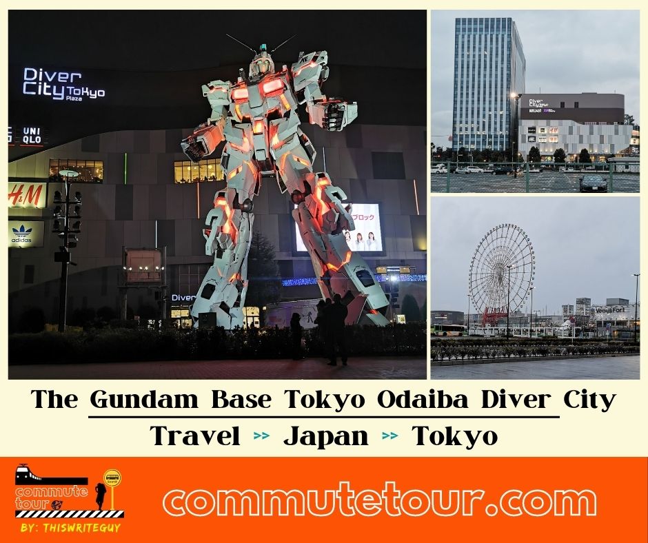
Odaiba Diver City
Odaiba Palette Town
Shinagawa Aquarium
Sony ExploraScience
Teamlab Borderless Tokyo
The Gundam Base Tokyo Odaiba Diver City
Tokyo Big Sight
Tokyo Joypolis
Zepp Tokyo
Shimbashi Station
Lines: JR Keihin-Tohoku Line, JR Tokaido Line, JR Yamanote Line, JR Yokosuka Line, Toei Asakusa Line, Tokyo Metro Ginza Line, Yurikamome Line
Operators: JR East, JR Central, Toei, Tokyo Metro, Yurikamome
Alternate Station: Shiodome
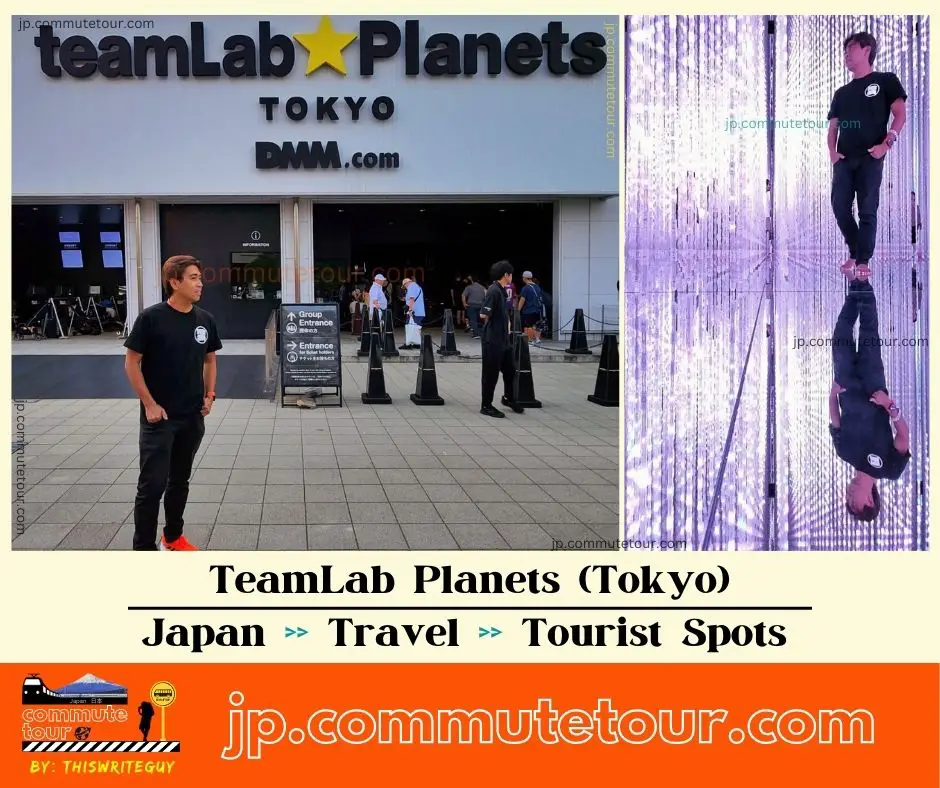
Tourist Spots: Ghibli Clock Ginza Shopping Street Panasonic Living Showroom Takarazuka Theater Teamlab Planets TokyoShiodome Station
Lines: Toei Oedo Line, Yurikamome Line
Operators: Toei, Yurikamome
Alternate Station: Shimbashi
Tourist Spots: Hamarikyu Gardens Panasonic Living Showroom Shiodome Sio-SiteOdaiba-Kaihin-Koen Station
Line: Yurikamome Line
Operator: Yurikamome
Alternate Stations: Aomi, Tokyo-Teleport
Tourist Spots: Odaiba Beach Park Odaiba Diver City Odaiba Palette Town Sony ExploraScience Statue of Liberty The Gundam Base Tokyo Odaiba Diver City Tokyo Joypolis Venus FortTelecom-Center Station
Line: Yurikamome Line
Operator: Yurikamome
Tourist Spots: Miraikan (National Museum of Emerging Science and Innovation) Zepp TokyoAomi Station
Line: Yurikamome Line
Operator: Yurikamome
Alternate Stations: Odaiba-Kaihin-Koen, Tokyo-Teleport
Tourist Spots: Odaiba Beach Park Odaiba Diver City Odaiba Palette Town Sony ExploraScience Teamlab Borderless Tokyo The Gundam Base Tokyo Odaiba Diver City Tokyo Joypolis Toyota Mega Web Venus Fort Zepp TokyoTokyo Big Sight Station
Line: Yurikamome Line
Operator: Yurikamome
Tourist Spots: Ariake Coliseum Ariake Tennis-no-mori Panasonic Center Tokyo Tokyo Big SightAriake Station
Line: Yurikamome Line
Operator: Yurikamome
Alternate Station: Kokusai-Tenjijo
Tourist Spot: Ariake Tennis-no-moriAriake Tennis-No-Mori Station
Line: Yurikamome Line
Operator: Yurikamome
Tourist Spots: Ariake Coliseum Tokyo Big Sight Toyosu MarketShin-Toyosu Station
Line: Yurikamome Line
Operator: Yurikamome
Tourist Spots: Lalaport Toyosu Teamlab Planets Tokyo Toyosu MarketToyosu Station
Terminal: Toyosu
Lines: Tokyo Metro Yurakucho Line, Yurikamome Line
Operators: Tokyo Metro, Yurikamome
Tourist Spots: Lalaport Toyosu Teamlab Planets Tokyo Toyosu Market
Toyosu Station
Terminal: Toyosu
Lines: Tokyo Metro Yurakucho Line, Yurikamome Line
Operators: Tokyo Metro, Yurikamome
Tourist Spots: Lalaport Toyosu Teamlab Planets Tokyo Toyosu MarketShin-Toyosu Station
Line: Yurikamome Line
Operator: Yurikamome
Tourist Spots: Lalaport Toyosu Teamlab Planets Tokyo Toyosu MarketAriake Tennis-No-Mori Station
Line: Yurikamome Line
Operator: Yurikamome
Tourist Spots: Ariake Coliseum Tokyo Big Sight Toyosu MarketAriake Station
Line: Yurikamome Line
Operator: Yurikamome
Alternate Station: Kokusai-Tenjijo
Tourist Spot: Ariake Tennis-no-moriTokyo Big Sight Station
Line: Yurikamome Line
Operator: Yurikamome
Tourist Spots: Ariake Coliseum Ariake Tennis-no-mori Panasonic Center Tokyo Tokyo Big SightAomi Station
Line: Yurikamome Line
Operator: Yurikamome
Alternate Stations: Odaiba-Kaihin-Koen, Tokyo-Teleport
Tourist Spots: Odaiba Beach Park Odaiba Diver City Odaiba Palette Town Sony ExploraScience Teamlab Borderless Tokyo The Gundam Base Tokyo Odaiba Diver City Tokyo Joypolis Toyota Mega Web Venus Fort Zepp TokyoTelecom-Center Station
Line: Yurikamome Line
Operator: Yurikamome
Tourist Spots: Miraikan (National Museum of Emerging Science and Innovation) Zepp TokyoOdaiba-Kaihin-Koen Station
Line: Yurikamome Line
Operator: Yurikamome
Alternate Stations: Aomi, Tokyo-Teleport
Tourist Spots: Odaiba Beach Park Odaiba Diver City Odaiba Palette Town Sony ExploraScience Statue of Liberty The Gundam Base Tokyo Odaiba Diver City Tokyo Joypolis Venus FortShiodome Station
Lines: Toei Oedo Line, Yurikamome Line
Operators: Toei, Yurikamome
Alternate Station: Shimbashi
Tourist Spots: Hamarikyu Gardens Panasonic Living Showroom Shiodome Sio-SiteShimbashi Station
Lines: JR Keihin-Tohoku Line, JR Tokaido Line, JR Yamanote Line, JR Yokosuka Line, Toei Asakusa Line, Tokyo Metro Ginza Line, Yurikamome Line
Operators: JR East, JR Central, Toei, Tokyo Metro, Yurikamome
Alternate Station: Shiodome
Tourist Spots: Ghibli Clock Ginza Shopping Street Panasonic Living Showroom Takarazuka Theater Teamlab Planets Tokyo
You can also check the full list of Tourist Spots along Yurikamome Line here.
Yurikamome Line Map
Yurikamome Line Shimbashi to Toyosu Map
Yurikamome Line Map
Yurikamome Line Station List
Yurikamome Line Station List: Shimbashi – Shiodome – Takeshiba – Hinode – Shibaura-Futo – Odaiba-Kaihin-Koen – Daiba – Tokyo International Cruise Terminal – Telecom-Center – Aomi – Tokyo Big Sight – Ariake – Ariake Tennis-No-Mori – Shijo-Mae – Shin-Toyosu – Toyosu
Yurikamome Line Details
| Line Name: | Yurikamome Line |
| Operator: | Yurikamome Inc. |
| Line Color (Hex): | #0065A6 Blue |
| # of Stations: | 16 |
| Origin: | Shimbashi |
| Destination: | Toyosu |
Yurikamome Line from Shimbashi to Toyosu passes along Toyosu Terminal.
The Yurikamome Line also connects with around 8 lines operated by JR Central, JR East, Tokyo Metro and Toei
| Operator | Lines and Transfer Stations |
|---|---|
| JR Central | JR Tokaido Line [Shimbashi] |
| JR East | JR Keihin-Tohoku Line [Shimbashi] JR Yamanote Line [Shimbashi] JR Yokosuka Line [Shimbashi] |
| Tokyo Metro | Tokyo Metro Ginza Line [Shimbashi] Tokyo Metro Yurakucho Line [Toyosu] |
| Toei | Toei Asakusa Line [Shimbashi] Toei Oedo Line [Shiodome] |
Tourist Spots along Yurikamome Line
The Tourist spots along the Yurikamome Line include
Ariake Coliseum
Ariake Tennis-no-mori
Decks Tokyo Beach
Ghibli Clock
Ginza Shopping Street
Hamarikyu Gardens
Lalaport Toyosu
Miraikan (National Museum of Emerging Science and Innovation)
Odaiba Beach Park
Odaiba Diver City
Odaiba Palette Town
Panasonic Center Tokyo
Panasonic Living Showroom
Shiodome Sio-Site
Sony ExploraScience
Statue of Liberty
Takarazuka Theater
Teamlab Borderless Tokyo
Teamlab Planets Tokyo
The Gundam Base Tokyo Odaiba Diver City
Tokyo Big Sight
Tokyo Joypolis
Toyosu Market
Toyota Mega Web
Venus Fort
Zepp Tokyo
Zojo-ji Temple
Featured